
Geology
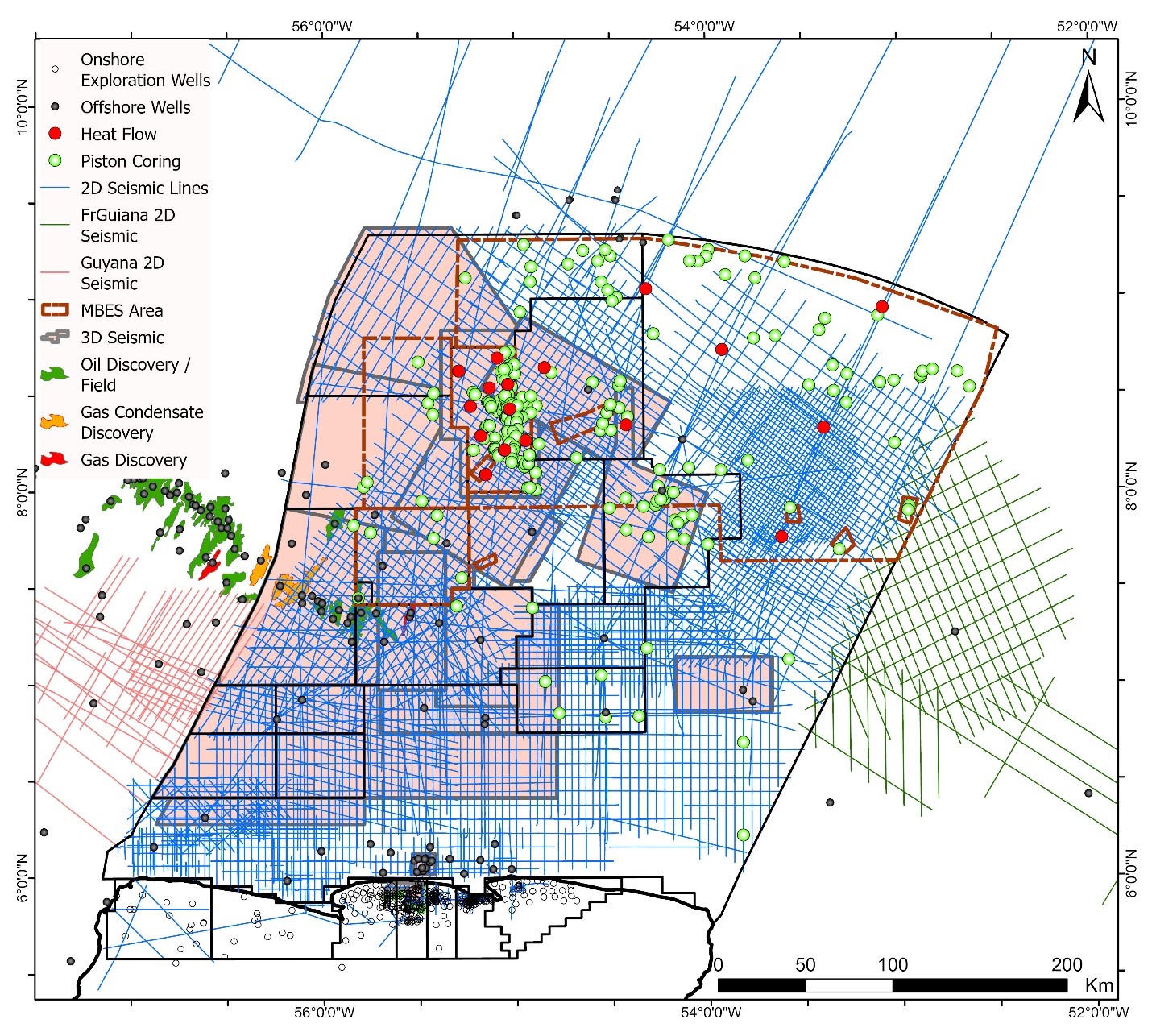
Suriname Part of the Suriname-Guyana Basin Showing Wells, Discoveries and Data Acquired
The Suriname-Guyana Basin formed as a passive margin during the separation of North America from South America/ Africa during the Early Jurassic and the subsequent separation of South America and Africa during the Early Cretaceous. The basin has several proven petroleum systems and has been producing hydrocarbons commercially since 1982. Proven reserves exceed 700 MMbls and production is due to increase from the current 17 000 bopd to at least 240 000 bopd when production in the offshore starts by 2028.
Several Cretaceous source rocks have been proven by drilling, with the Albian to Coniacian (ACTC) being the most prolific to date, generating under an Early Tertiary progradational wedge. Proven reservoirs comprise high quality Cretaceous and Tertiary sandstones, with additional potential in carbonates and older rocks. Trapping is largely stratigraphic, effected by southerly onlap and pinch-out, and lateral facies change.
Drilling density in the basin remains low and only approximately 50% of the on/offshore acreage is currently licensed. New datasets such as multi-beam bathymetry and piston cores are continually being acquired, complementing the existing and growing database of 3D and 2D seismic and gravity/magnetics.
Since exploration drilling began in 1963 approximately 60 exploration wells have been drilled offshore, with a further 250 or so onshore, where heavy oil was discovered in Paleocene-Eocene sandstones in 1965. Three onshore fields are currently at peak production of 17 000 bopd from Paleo-Eocene fluvial to tidal sandstone reservoirs.
In time, 2D and 3D seismic data acquisition and exploration drilling have moved northwards into deeper water, as well as eastwards onto the Demerara Plateau. Approximately 50% of the offshore basin is currently licensed and covered by 3D seismic data, with new acquisition and reprocessing planned. Following massive exploration success offshore Guyana from 2014, that trend was successfully extended into Suriname with Apache’s Maka Central oil and gas discovery in 2019.
Since then, several further discoveries have been made, in the same Santonian to Maastrichtian slope/turbidite sand reservoir facies. On 1st October 2024 Suriname and Total announced development approval for Gran Morgu, which is due onstream at 220 000 bopd in 2028.

 Exploration Wells Drilled and Seismic Data Acquired Over Time, Suriname-Guyana Basin (Suriname)
Several recent studies by Staatsolie have used the legacy well, seismic and gravity/magnetic database to update and improve the geological understanding of the Suriname-Guyana Basin.

Schematic South-North Regional Cross Section of the Suriname-Guyana Basin

Key Elements in the Development of the Suriname-Guyana Basin Petroleum System

Schematic Regional Cross Section of the Suriname-Guyana Basin, Showing Proven and Potential Trap Types
The basin comprises a clastic wedge which onlaps and thins southwards onto Proterozoic continental crust of the Guiana Shield. During end Triassic times the northern margin of the shield was intruded by the Central Atlantic Magmatic Province (CAMP), initially forming graben features such as the Nickerie and Commewijne. This magmatism evolved into SDRs (Seaward Dipping Reflector) packages and eventually oceanic crust during the Early Jurassic, as Florida and North America moved northwestward away from Suriname/Guyana along a sinistral transform margin. The Demerara Plateau represents a northeastward continuation of the South American craton which was variously intruded by CAMP magmatism. Middle Jurassic to Early Cretaceous (Aptian) sediments comprise shallow marine, passive margin clastics and carbonates which progressively onlap the igneous basement towards the south.
The opening of the Equatorial Atlantic was preceded by a counterclockwise rotation of Africa against South America, resulting in several unconformities, formation of a fold/thrust belt in the northern offshore area, removal of over 2km of sediment and peneplanation of the Demerara Plateau, dextral transpression, and subsequent gravity collapse from the western margin of that Plateau. Since the Late Albian a second passive margin has developed, again with progressive onlap and pinch-out towards the south and southeast, with sediments supplied by large rivers from the emergent Guiana Shield further south. 3D seismic and facies analyses allow the mapping of subtle changes in depositional gradient and direction towards the north during the mid to late Cretaceous and as the Demerara Plateau structural high was gradually overstepped, its control on depositional trends diminished.

Main Stages of Tectonic Development Since the Jurassic for the Suriname-Guyana Basin
During the latest Cretaceous and Paleogene interactions between the Nazca Plate with western South America and the Caribbean Plate with northern South America, led to the rise of the Andes and rearrangement of regional drainage systems. In the Suriname-Guyana Basin, the result was a huge increase in sediment supply and rapid northward progradation of a clastic wedge with associated shelf instability, source rock maturation and generation of overpressure through compaction disequilibrium. Since the Miocene, strong currents have carried sediments into the Suriname-Guyana Basin and beyond, from as far south as the Amazon delta, resulting in a complex interplay with more locally derived clastics.
Due to its complex tectonic history, the basin has experienced minor phases of compressional and transpressional reactivation along old lineaments, up to Present Day.
The main productive plays in the basin comprise clastic Campanian-Maastrichtian turbidite channel and fan slope deposits offshore, and Paleocene-Eocene fluvial to tidal channels and bars onshore, charged within the last 5 Mya from the ACTC source rock in kitchens to the north and trapped by lateral facies change and minor faulting.

Mid Albian Gross Depositional Environment (GDE) Map for the Suriname-Guyana Basin (Suriname)
Reservoir: sandstone reservoirs ranging from Early Cretaceous to Oligocene in age have been drilled in the basin, in fluvial (south) to deep marine facies (north). Porosity and permeability are good to excellent, aided by shallow burial onshore, and late burial, overpressure and moderate geothermal gradients in the north. The main control on porosity evolution is compaction, followed by detrital lithofacies and late diagenesis. Shelf carbonates of Early Cretaceous and Paleogene age have been drilled but penetrations are few and high permeability facies have not yet been encountered.

Log-Derived Porosity (Zonal Averages) Versus Depth for Cretaceous and Tertiary Reservoirs in the Shallow Offshore of Suriname. Petrophysical Cut-Off Derived from Core Porosity Versus Permeability (1mD, for oil)
Source and Charge: With sufficient well data, we have been able to map individual source rock acmes within the ACTC (Albian, Cenomanian, Turonian, Coniacian), as well as intervals within the Aptian and older. These Type II source rocks (organofacies B) have been typed to the fluids encountered in the basin (mainly light oil and gas condensate with a typical oil API range of 28 - 37) and are modelled to have generated over 300 BNBbls of liquids, much of it within the last 5 Mya. We have used pressure data and mud-gas ratios to estimate the depth of the migration front from this late charge, relative to the reservoir horizons. The exception to light oil and condensate occur in the onshore fields due to shallow burial (300-600m below ground level) and long distance migration, which has resulted in low GOR, biodegraded oils with an API gravity range of 16-18.

Summation of Total Oil Expelled from ACTC (Albian-Coniacian), Aptian and Jurassic Source Rocks Offshore Suriname (from preliminary PSM model)
As well as the proven source rocks, the basin evolution and analogue studies suggest that rich, oil prone source rocks can be expected within the Jurassic to earliest Cretaceous section, and within the oil window in the eastern side of the basin.
Trapping: To date, successful traps in the basin were formed by stratigraphic pinch-out and lateral facies change, as sand-rich channels and lobes shale out. Trap integrity is aided by relatively minor tectonic deformation since late hydrocarbon charge, and excellent sealing characteristics from marine shales, which are able to support long hydrocarbon column heights. Additional trapping potential exists in sub-unconformity subcrop and karst (carbonate) plays, as well as in thrusted anticlines within the fold belt in the northern offshore area, west of the Demerara Plateau.
New data acquisition and analysis techniques are intended to unlock the large remaining potential of the Suriname-Guyana Basin. Much of this lies in shallow to moderate water depths and at reasonable drilling depths. We estimate the undrilled resource in just the open acreage at 6.8 BNBoe. The relevant plays have been described above and are summarized here for ease of reference:


Geo-seismic Cross Sections Illustrating Potential Reservoirs and Trap Types in the Suriname-Guyana Basin (Suriname)
Further Reading / Data Availability
Confidence in our own abilities
